Morrow County GenSoc-County Info usgenweb.gif OHGenWeb Project mtgilead.gif /morrow-oh.gif

Morrow County Ohio GenWeb Site


Photo in upper right was taken in the center of the Village of Mount Gilead, which is the Morrow County Seat. View is to the East, showing Victory Shaft and County Courthouse. The Victory Shaft was awarded to the citizens of Morrow County in December, 1919, for selling the most War Savings (Victory) Bonds per capita of any Ohio county during the 1919 Victory Bond Campaign.

From Four Came One

Morrow is one of Ohio's newest counties, having been formed February 24, 1848, from parts of Richland, Knox, Marion, and Delaware counties. Our new county then contained 258,560 acres of land, which were divided into sixteen townships and named for Jeremiah Morrow, a resident of Warren County and Governor of Ohio from 1822 to 1826.

Settlement of this area by "white folks" started in earnest after the War of 1812. However, there are at least two families believed to have settled in the county prior to the war: the Holt family possibly as early as 1806/7 in what is now Chester Township, and the Shaw family in 1808/9 in what is now Westfield Township.

Mount Gilead, the county seat, was laid out by Jacob Young on September 30, 1824, in what at the time was Marion County. Originally called Whetsom, the name of the village was changed to Mount Gilead in 1832 by the Ohio legislature; it was incorporated in 1839.

The Townships of Morrow County

When the surrounding counties gave up land for the formation of Morrow County, most of the new lines were drawn along existing Township lines. The primary exception is in what is now the center of Morrow County, see map. The colors represent land that prior to 1848 was in the "parent" county, i.e.: Purple = Marion; Yellow = Richland; Salmon = Delaware; Aqua = Knox.
townships.gif  
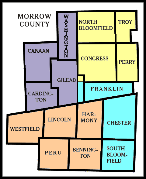
The Townships that came from Marion County (purple) are: Canaan, Washington, Cardington, and most of Gilead (some of what is  now Gilead was in Knox County).

 The Townships that came from Richland County (yellow) are: North Bloomfield, Troy, Congress, and Perry.

 The Townships that came from Delaware County (salmon) are: Westfield, Lincoln, Harmony, Peru, and Bennington.

 The Townships that came from Knox County (aqua) are: Franklin, Chester, and South Bloomfield.

 Many thanks to Jane Peppler for the map!

The sixteen townships, with the name of their parent county, are listed below in chronological order by date of initial settlement.
Chester (Knox)  1808
Westfield (Delaware)  1808
Peru (Delaware)  1809
Franklin (Knox)   1810
Bennington (Delaware)  1811
Perry (Richland)  1812
South Bloomfield (Knox)  1814
Troy (Richland)  1814-15
Gilead (Marion)  1817
Washington (Marion)  1818-19
North Bloomfield (Richland)  1820
Congress (Richland)  1820-21
Canaan (Marion)  1821
Cardington (Marion)  1822
Lincoln (Delaware)  1824
Harmony (Delaware)  1826

For researching purposes prior to 1848, go to the parent county's records.


Return to Morrow County GenWeb Home Page

This OHGenWeb site is provided by volunteers of the Morrow County Chapter of the Ohio Genealogical Society.
This page was last updated on: Monday, 10-Sep-2018 13:43:23 MDT


Copyright 2012 by the Morrow County Genealogical Society. All rights reserved.
This site may be freely linked to but not duplicated without consent.