Most of the cemetery names and locations were obtained from the results of a federally funded project in the 1930’s, known as the “WPA Veterans Grave Registration Project”. It was conducted in cooperation with the American Legion to identify the names of all veterans of the armed services buried in Morrow County and to locate their graves. A copy of the WPA survey is in the Recorder’s office in the Morrow County Courthouse, Mount Gilead, Ohio. In addition, over the years, volunteers from the Morrow County Genealogical Society have physically walked through every known cemetery area and, in most cases, were able to record the tombstone inscriptions and locations.
- Courtright Cemetery
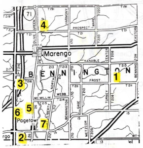
TR211 & TR208. About 1-1/4 miles south of SR229 and 2.75 miles southeast of Marengo. No Stones. 0.01 acre - Fargo Methodist Episcopal Cemetery
Fargo is at a cross road in the southwestern corner of Bennington Township, about 1/3 of a mile north of the Delaware-Morrow County line. Until 1848 this was a part of Delaware County. The cemetery is just east of the church on the south side of CR15, which crosses the Columbus-Mt. Gilead road (SR61) at Fargo. It is not a very large cemetery and is still in use. The oldest part seems to be to the east side and is somewhat neglected. The newer part is well cared for. One Revolutionary War soldier, William Steward, is buried here, and his grave has a government marker. If there are others, the graves do not appear to be marked. All legible inscriptions in the east part, beyond the gate, were copied; and quite a number of the older inscriptions in the new section. 1.25 acres. Copied October 3, 1993 by G. S. Morgan. - Fargo North, Butter, Vining Cemetery
Formerly a part of Delaware County. This is all that is left of a rather small old cemetery, about two miles north of the Delaware-Morrow County line, and 1-3/4 miles north of the cross road at Fargo, formerly called Morton’s Corners. It is to the east side of the Columbus-Mt. Gilead Road (SR61) and perhaps 300 feet back from the road, near TR216. It has been used as a pasture field, some of the stones are down, and apparently there are many unmarked graves. Inscriptions on 25 stones were copied May 27, 1948. Then on October 2, 1993, G. S. Morgan copied another 10 more recent stones. 3 acres. - Marengo Cemetery
Located one mile north of Marengo at the intersection of CR26 and TR21. On the west side of CR26. The old section is on the south side of TR21, while the new section is on the north side. Copied September 1993 by G. S. Morgan. 3.5 acres. - Pagetown/Wilson Cemetery
Until 1848 a part of Delaware County. This is a little old burying ground about a mile north of Pagetown, near the intersection of TR215, and to the west side of CR26, about 20 rods or so back from the road across a cornfield. The fence is practically gone, and apparently cattle have been ranging through this place. It is fairly well grown up with rather small trees. Many stones are fallen and more or less covered, others broken, some beyond reading, also some weathered and illegible. All inscriptions that could be read were copied. There are many unmarked sunken graves. Copied May 27, 1948 (which is when the above description was written.) 0.52 acres. - Sherman Family Burying Ground
This has been a small family burial plot and is almost gone. Two legible stones remain, one broken and fallen, and the bases for three others still remain, but the stones themselves gone. What may be the base of a fourth stone – a block of heavy sandstone – looks as if it had been removed from its original position. This spot is on the east side of SR61 and perhaps a mile north of Fargo. It is a mile south of the old Vining Cemetery. The present Delaware-Morrow County line is 1 or 1-1/2 miles south of this Sherman Cemetery. At the time of the first burials it was part of Delaware County. The cemetery is in a field directly opposite the site of the old Sherman homestead, now torn away and replaced by the recently built home of Bob Richeson. The house was built about 1825-1827 of brick. Mr. Sherman at that time owned 3,000 acres which he got from the government on Revolutionary Service. Copied March 17, 1952 (which is when the preceding was written.) 0.25 acre. - Smith Cemetery
Northwest of intersection of CR212 and CR15, one mile east of Pagetown. No stones. 0.25 acre.
