Most of the cemetery names and locations were obtained from the results of a federally funded project in the 1930’s, known as the “WPA Veterans Grave Registration Project”. It was conducted in cooperation with the American Legion to identify the names of all veterans of the armed services buried in Morrow County and to locate their graves. A copy of the WPA survey is in the Recorder’s office in the Morrow County Courthouse, Mount Gilead, Ohio. In addition, over the years, volunteers from the Morrow County Genealogical Society have physically walked through every known cemetery area and, in most cases, were able to record the tombstone inscriptions and locations.
GPS coordinates, where listed, are from the USGS Geographic Names Information Service (GNIS) here.
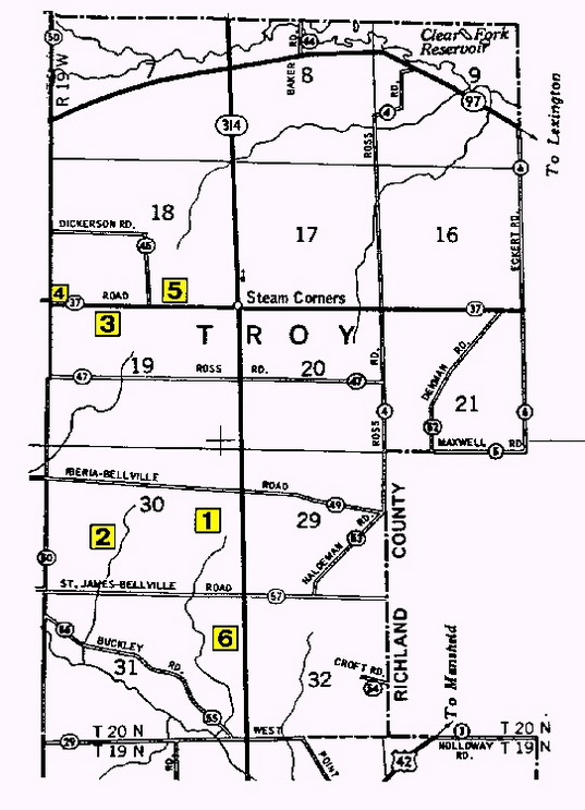
- Haldeman Cemetery
GPS Coordinates: Latitude 40.6592251 and Longitude -82.6665632 0.44 Acres. Located in the NW quarter of Section 30. West of the Chesterville-Shelby Road (SR 314) and south of the Iberia-Bellville Road (TR 49). Copied September 1977. - Hassler Cemetery
GPS Coordinates: None available.
Located in Section 30 approximately 0.3 mile south of the Iberia-Bellville Road (TR 49) and east of the Chestnut Ridge Road (TR 50). - Ross Cemetery
GPS Coordinates: Latitude 40.6811692 and Longitude -82.6815642
Located in the NW quarter of Section 19. On the south side of the Steam Corners-Lexington Road (CR 37) approximately 0.8 mile west of Steam Corners, between TR 50 and TR 45. Copied April 1981. - Stull Cemetery
GPS Coordinates: None available.
Located in the intersection of Steam Corners-Lexington Road (CR 37) and Chestnut Ridge Road (CR 50). Location and information from WPA Veterans Grave Registration Project: “Note: Man buried here, who died while working on road many years ago. He wished to be buried where he worked. His name is unknown.” - Unnamed Cemetery
GPS Coordinates: None available.
Located in SE quarter of Section 18. On north side of Steam Corners-Lexington Road (CR 37) approximately one-half mile west of Steam Corners, but east of Dickerson Road (TR 45). Copied March 1983. - Walters Cemetery
GPS Coordinates: Latitude 40.6478364 and Longitude -82.6637851
Located in the NE quarter of Section 31. On the west side of SR 314 south of the St. James-Bellville Road (CR 57).